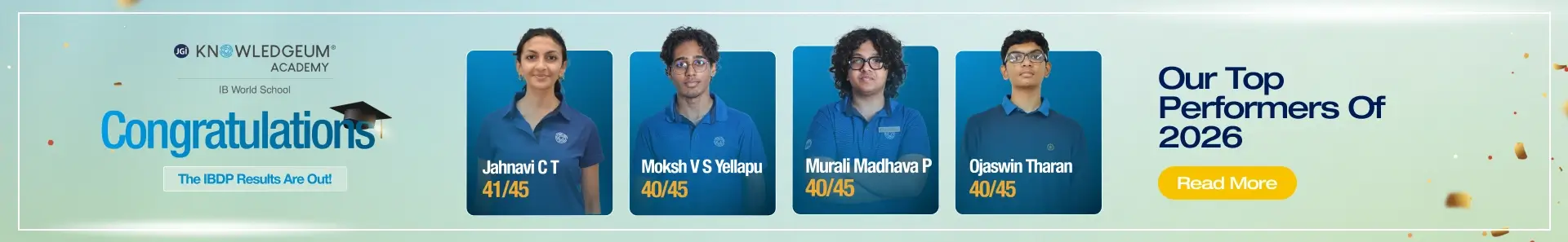
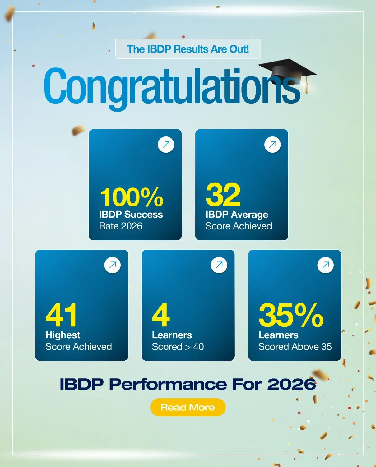
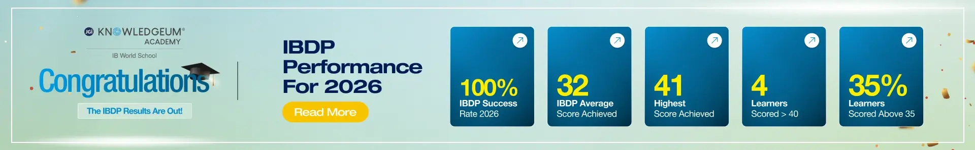
Bangalore (Namma) Metro currently has 3 operational lines and 3 more under construction / planning, making it a fast-growing urban rail network.
Bangalore Metro Operational Lines
- Purple Line (Kengeri ↔ Whitefield (Kadugodi))
- East–West Corridor, ~43 km
- Key stations: Kengeri, Mysore Road, Majestic, MG Road, Indiranagar, KR Puram, Whitefield
- Green Line (Nagasandra ↔ Silk Institute)
- North–South Corridor, ~33 km
- Key stations: Nagasandra, Yeshwanthpur, Majestic, Lalbagh, Jayanagar, Banashankari, Silk Institute
- Yellow Line (RV Road ↔ Bommasandra)
- ~19 km, opened in August 2025
- Connects Electronic City & Bommasandra industrial hub
Bangalore Metro Under Construction Lines
- Pink Line (Kalena Agrahara ↔ Nagawara)
- ~21 km, mostly underground through city center
- Key areas: Dairy Circle, MG Road (link), Shivajinagar, Cantonment
- Blue Line (Central Silk Board ↔ Kempegowda International Airport)
- ~58 km, Airport Corridor
- Key interchanges: KR Puram, Nagawara, Hebbal → direct link to Airport
Bangalore Metro Proposed Line
- Orange Line (Hebbal ↔ Sarjapur)
- ~37 km, Phase 3 proposal
- Aimed at decongesting ORR & Sarjapur IT corridor
Summary:
- 3 lines operational (Purple, Green, Yellow) → ~96 km
- 2 lines under construction (Pink, Blue) → completion by 2027–28
- 1 line proposed (Orange) → Phase 3, post-2025
Bangalore Metro Purple Line – East–West Corridor
The Purple Line was the first metro corridor to be introduced in Bangalore under Namma Metro. It runs from Whitefield (Kadugodi) in the east to Challaghatta in the west, covering a total distance of 43.49 km with 37 stations (including the extensions completed in 2023).
Key Stations on the Purple Line:
- Baiyappanahalli
- Indiranagar
- MG Road
- Cubbon Park
- Majestic (Interchange with Green Line)
- Vijayanagar
- Mysore Road
- Kengeri
- Challaghatta
- Whitefield (Kadugodi)
Highlights:
- First operational line of Namma Metro, opened in 2011.
- Connects the major IT corridor of Whitefield with the central business district (MG Road, Cubbon Park).
- Interchange at Majestic allows seamless transfers between Purple and Green Lines.
- Passes through some of the busiest and most significant parts of the city, easing daily travel for lakhs of professionals working in tech parks, offices, and commercial hubs.
Bangalore Metro Green Line – North–South Corridor
The Green Line is the second major line of Namma Metro, running from Madavara (Nagasandra) in the north to Silk Institute in the south, covering 33.5 km with 30 stations.
Key Stations on the Green Line:
- Nagasandra
- Yeshwanthpur
- Sampige Road (Malleshwaram)
- Majestic (Interchange with Purple Line)
- Lalbagh
- Jayanagar
- Banashankari
- Yelachenahalli
- Silk Institute
- Rashtreeya Vidyalaya Road (Interchange with Yellow Line)
Highlights:
- Opened in phases between 2014 and 2017.
- Serves major residential and industrial zones including Peenya, Malleshwaram, Jayanagar, and Kanakapura Road.
- Provides two major interchange points:
- Majestic → with the Purple Line.
- RV Road → with the newly opened Yellow Line (2025).
- Plays a crucial role in connecting northern Bangalore’s industrial belt with the southern residential areas.
Bangalore Metro Yellow Line – South-East Corridor
The Yellow Line is the newest addition to Namma Metro, inaugurated on 10 August 2025. It runs from Rashtreeya Vidyalaya Road (RV Road) in South Bangalore to Bommasandra in the industrial and IT hub of Electronics City, covering a distance of 18.82 km with 16 elevated stations.
Key Stations on the Yellow Line:
- Rashtreeya Vidyalaya Road (Interchange with Green Line)
- Jayanagar East
- Jayadeva Hospital (future interchange with Pink Line)
- Dairy Circle
- Hulimavu
- Gottigere
- Electronic City I
- Electronic City II
- Bommasandra
Highlights:
- Inaugurated by the Prime Minister on 10 August 2025, marking Phase 2 progress of Namma Metro.
- Connects central Bangalore to Electronics City, one of the largest IT and industrial hubs in India.
- Provides a much-needed transport link for thousands of professionals working in tech parks, industries, and educational institutions along Hosur Road.
- Key interchange at RV Road station allows easy switching between the Green and Yellow Lines.
- Expected to drastically reduce travel times from Electronics City to central Bangalore.
Bangalore Metro Blue Line – Airport Corridor (Phase 2B)
The Blue Line is one of the most ambitious metro projects under Phase 2B of Namma Metro. It will connect Central Silk Board in the south to Kempegowda International Airport (KIA) in the north, covering a distance of about 58 km with more than 30 stations. Once completed, it will be the longest metro corridor in Bangalore.
Key Stations on the Blue Line:
- Central Silk Board (Interchange with Yellow Line)
- KR Puram (Interchange with Purple Line)
- Nagawara (Interchange with Pink Line)
- Hebbal (Interchange with Orange Line & Green Line extension)
- Yelahanka
- Airport Trumpet
- Kempegowda International Airport (KIA Terminal)
Highlights:
- Provides direct connectivity from central Bangalore to Kempegowda International Airport, reducing travel time from nearly 2 hours by road to under 1 hour.
- Major interchange hubs at Silk Board, KR Puram, Nagawara, and Hebbal, making it a backbone corridor of the future metro grid.
- Planned with larger stations and longer trains to handle heavy passenger volumes, especially airport traffic.
- Construction is in progress, and the line is expected to be operational by 2028.
With Purple, Green, and Yellow already operational (~96 km), and Blue + Orange + Pink Lines on the way, Bangalore Metro is set to become a 300+ km network by 2035, making it one of India’s largest urban transit systems.
Bangalore Metro Pink Line – Underground Corridor (Phase 2)
The Pink Line is an upcoming underground metro corridor under Phase 2 of Namma Metro. It will stretch from Kalena Agrahara (Gottigere) in the south to Nagawara in the north, covering about 21.3 km with 18 stations. Most of the route will be underground, passing through some of Bangalore’s busiest central areas.
Key Stations on the Pink Line:
- Kalena Agrahara (Gottigere)
- Jayadeva Hospital (Interchange with Yellow Line)
- Dairy Circle
- Lalbagh
- MG Road (Pedestrian link with Purple Line)
- Shivajinagar
- Cantonment Railway Station
- Pottery Town
- Nagawara (Interchange with Blue Line)
Highlights:
- First fully underground metro line in Bangalore.
- Connects major business and commercial hubs like MG Road, Shivajinagar, and Cantonment.
- Important interchanges at Jayadeva Hospital (Yellow Line), MG Road (Purple Line), and Nagawara (Blue Line).
- Expected to be operational by 2027–2028.
Bangalore Metro Orange Line – East–South Corridor (Proposed, Phase 3)
The Orange Line is a proposed metro corridor under Phase 3 of Namma Metro. Once built, it will run from Hebbal in the north to Sarjapur Road in the southeast, covering approximately 37 km with multiple interchange points.
Key Stations on the Orange Line:
- Hebbal (Interchange with Blue Line & Green Line extension)
- Hennur
- Koramangala
- Agara
- Iblur
- Sarjapur
Highlights:
- Planned to decongest the Outer Ring Road (ORR) and Sarjapur Road, two of Bangalore’s busiest IT and residential corridors.
- Will serve thousands of commuters in Koramangala, HSR Layout, Bellandur, and Sarjapur IT hubs.
- Hebbal will act as a major interchange, linking the Orange Line with the Blue Line (Airport Corridor) and Green Line extension.
- Currently in the planning stage, with construction likely to begin after 2025.
Bengaluru Metro (Namma Metro) – Operational & Upcoming Lines Overview
| Line | Route | Length (Approx.) | Key Interchanges | Status (2025) | Highlights |
| Purple Line | Whitefield (Kadugodi) ↔ Challaghatta | 43.5 km, 37 stations | Majestic (with Green Line) | Operational (2011, extended 2023) | First metro line in Bangalore; connects Whitefield IT hub with city centre. |
| Green Line | Madavara (Nagasandra) ↔ Silk Institute | 33.5 km, 30 stations | Majestic (with Purple Line), RV Road (with Yellow Line) | Operational (2014–2017) | Links northern industrial belt with southern residential areas. |
| Yellow Line | RV Road ↔ Bommasandra | 18.8 km, 16 stations | RV Road (with Green Line), Jayadeva Hospital (future with Pink Line) | Operational (Aug 2025) | Connects Electronic City IT hub with central Bangalore. |
| Blue Line | Central Silk Board ↔ KIA Airport | 58 km, 30+ stations | Silk Board (with Yellow Line), KR Puram (with Purple Line), Nagawara (with Pink Line), Hebbal (with Orange & Green Line extension) | Under Construction (Phase 2B, est. 2028) | Direct airport connectivity; longest metro line in Bangalore. |
| Pink Line | Kalena Agrahara (Gottigere) ↔ Nagawara | 21.3 km, 18 stations | Jayadeva Hospital (with Yellow Line), MG Road (with Purple Line via link), Nagawara (with Blue Line) | Under Construction (Phase 2, est. 2027–28) | First fully underground metro line; passes through city’s busiest hubs. |
| Orange Line | Hebbal ↔ Sarjapur Road | 37 km (planned) | Hebbal (with Blue Line & Green Line extension) | Proposed (Phase 3, post-2025) | Planned to decongest ORR & Sarjapur IT corridor. |